
 Print
Why are the City of Surrey and City of Vancouver Covid-19 cases shown differently?
11-17-2020
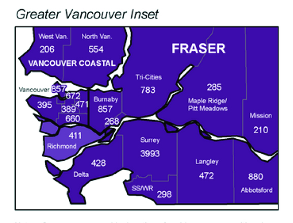
If you look at the map below one can be mislead to believe the City Surrey has the most cases of Covid-19 in all of BC.
That begs the question many Surrey residents are asking, Why are the City of Surrey and City of Vancouver Covid-19 cases shown differently?
The answer may be very simple. The map Map shows Covid-19 cases based on Local Health Areas.
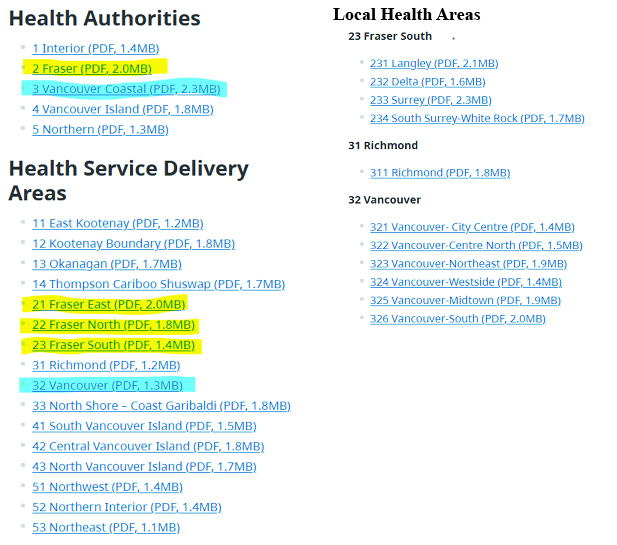
As per the BC Government website, the Health Administrative Boundaries are based on a nested hierarchy. At the very top are the Five Regional Health Authorities followed by Sixteen Community Service Health Areas which is again followed by various Local Health Areas.
The explanation can been seen below how The city of Vancouver is divided into 6 Local Health Areas while the City of Surrey is a single Local Health Area.
If you add up all the Covid-19 cases as shown in the Local Health Areas as of November 10, 2020, the city of Vancouver (857+672+471+389+660+395) totals 3444 while the City of Surrey total is 3993. The City of Surrey numbers are higher than the City of Vancouver but if you compare the rate per 100,000 both Cities are almost similar and have greater than 200 per 100,000 residents.
.png)
Health Authorities
1 Interior
2 Fraser
3 Vancouver Coastal
4 Vancouver Island
5 Northern
Community Health Service Delivery Areas
11 East Kootenay
12 Kootenay Boundary
13 Okanagan
14 Thompson Cariboo Shuswap
21 Fraser East
22 Fraser North
23 Fraser South
31 Richmond
32 Vancouver
33 North Shore – Coast Garibaldi
41 South Vancouver Island
42 Central Vancouver Island
43 North Vancouver Island
51 Northwest
52 Northern Interior
53 Northeast
Local Health Areas
23 Fraser South
231 Langley (PDF, 2.1MB)
232 Delta (PDF, 1.6MB)
233 Surrey (PDF, 2.3MB)
234 South Surrey-White Rock (PDF, 1.7MB)
31 Richmond
311 Richmond (PDF, 1.8MB)
32 Vancouver
321 Vancouver- City Centre (PDF, 1.4MB)
322 Vancouver-Centre North (PDF, 1.5MB)
323 Vancouver-Northeast (PDF, 1.9MB)
324 Vancouver-Westside (PDF, 1.4MB)
325 Vancouver-Midtown (PDF, 1.9MB)
326 Vancouver-South (PDF, 2.0MB)
Resources:
https://www2.gov.bc.ca/gov/content/data/geographic-data-services/land-use/administrative-boundaries/health-boundaries
Footnotes:
|